Fire Hazard Severity Zones
The History of Fire Hazard Severity Zone (FHSZ) Maps
Fire Hazard Severity Zone maps arose from major destructive fires, prompting the recognition of these areas and strategies to reduce wildfire risks. Legislative response led to mandated mapping across California under the California Public Resources Code 4201-4204, encompassing all State Responsibility Areas (SRA).
What are Fire Hazard Severity Zones?
The State Fire Marshal is mandated to classify lands within State Responsibility Areas into Fire Hazard Severity Zones (FHSZ). Fire Hazard Severity Zones fall into one of the following classifications:
- Moderate
- High
- Very High
The California laws that require Fire Hazard Severity Zones include California Public Resources Code 4201-4204, California Code of Regulations Title 14, Section 1280 and California Government Code 51175-89.
Frequently Asked Questions
The maps assess wildfire hazard levels based on physical conditions that contribute to fire spread, helping to guide building codes, emergency planning, and fire safety regulations. Reminder: You are not at less risk just because you are in a lower hazard zone.
No, the maps themselves do not determine insurance rates. However, catastrophic risk data, which includes wildfire hazard information, is often considered in fire insurance modeling. See the available FAQs on this topic: Insurance Q&A from Insurance Commissioner Ricardo Lara
Areas are classified into three hazard levels: moderate, high, and very high based on factors like fuel availability, topography, and historical fire weather patterns.
No. The local agency cannot decrease the level of fire hazard severity zones as identified on the State Fire Marshal maps. Government Code 51179(b)(3). The local agency can do the following:
- Include areas within the District, Town or County not identified as very high fire hazard severity zones by the State Fire Marshal, as very high fire hazard severity zones following a finding supported by substantial evidence in the record that such designations are necessary for effective fire protection within the area. Government Code 51179(b)(1).
- Include areas within the District, Town or County, not identified as moderate and high fire hazard severity zones by the State Fire Marshal, as moderate and high fire hazard severity zones, respectively. Government Code 51179(b)(2).
- Increase the level of fire hazard severity zone as identified by the State Fire Marshal for any area within the District, Town or County. Government Code 51179(b)(3). 2
No. The adoption of the State Fire Marshal maps does not impact the District’s Fire Code. The adoption of the State Fire Marshal maps does not limit or restrict the authority of the District to impose more restrictive fire and public safety requirements, as otherwise authorized by law. Government Code 51175(c). The District may adopt ordinances, rules, or regulations to provide fire prevention restrictions or regulations that are necessary to meet local conditions of weather, vegetation, or other fire hazards. Such ordinances, rules, or regulations may be more restrictive than state statutes in order to meet local fire hazard conditions. Public Resources Code 4117.
Current Map of Fire Hazard Severity Zones in Montecito
Open the Fire Hazard Severity Zones Lookup Map in a new window.
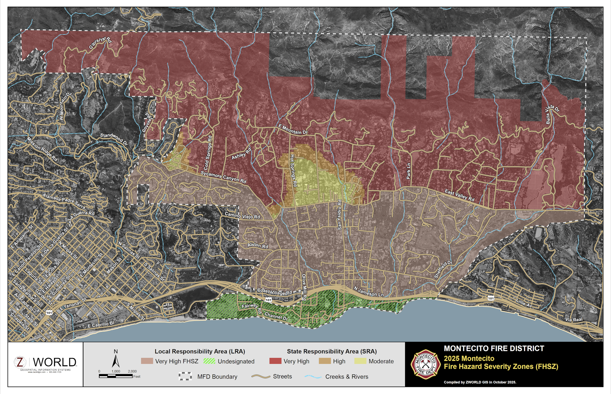
The State’s Fire Hazard Severity Zone (FHSZ) maps are valuable tools for predicting wildfire spread through wildland vegetation based on fuels, topography, and weather. However, these models stop at the edge of communities and do not necessarily reflect what happens when wildfire transitions into the built environment, where embercast and structure-to-structure fire spread become dominant drivers of destruction.
Recent field observations from the Palisades and Eaton Fires in Los Angeles County reinforce what decades of fire history have already shown us: in dense neighborhoods, it's not the flames from the wildlands that cause the greatest loss, but the urban conflagration that follows. Embers—carried by wind—can ignite homes far beyond mapped fire perimeters. Once a few structures ignite, radiant heat and short-range ember generation can rapidly spread fire from building to building, overwhelming even fire-resistant materials when homes are tightly spaced or connected by combustible features like fences, vegetation, or decks.
In these conditions, structure separation, connective fuels, and building materials all combine to determine whether fire will continue to spread or be stopped. A recent Insurance Institute for Business & Home Safety (IBHS) report concluded that with only 10 feet between homes, no known building material reliably survives downwind exposure. At 20 feet, fire-resistant materials start to make a difference—but that margin doesn’t exist in many neighborhoods.
Our local maps incorporate these real-world fire dynamics, going beyond vegetation modeling to highlight where fire is likely to behave more aggressively due to community density and structural vulnerability. By using fire history and known pathways of ember-driven ignition, these maps better identify areas at risk for urban conflagration and justify a Very High Fire Hazard Severity Zone (VHFHSZ) designation.